
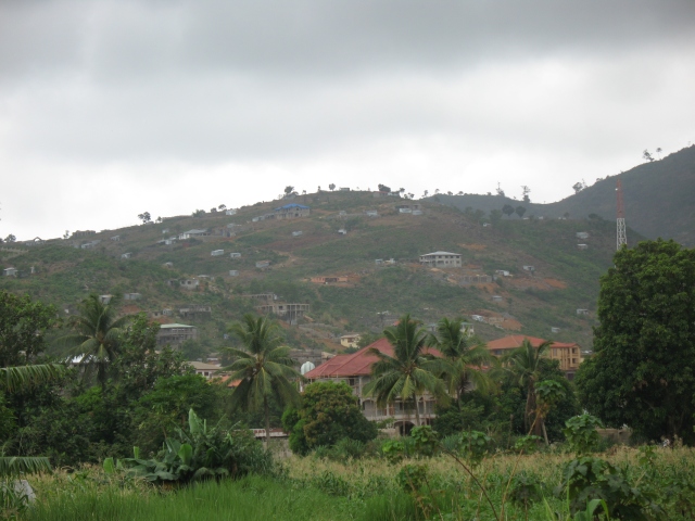
For some years now, at the height of Sierra Leone’s rainy season, heavy floods have struck the country’s capital city, Freetown, leaving behind them damaged infrastructure and devastated housing.[1] This year, again, floods claimed several lives in Freetown and paralyzed the city for days. Nearby towns on the Peninsula, like Wellington and Tombo, were also affected by heavy flooding, which claimed still more casualties. As rains fell heavily throughout August, the fear of a mass tragedy became very much alive in discussions among Sierra Leoneans living in the European diaspora. Just two years ago, on August 14th 2017, a mudslide at Mount Sugar Loaf took the lives of a thousand people and left three thousand others homeless. The risk of landslide was known to the government.[2] The clearing of that hill, which falls into the forest reserve, had already been declared illegal by the Ministry of Lands in 2012.[3] It has now become clear that unregulated housing construction on the hillsides that surround Freetown strongly amplify risks of flooding and landslides. Deforestation not only increases soil erosion, but construction also raises those risks by clogging the city’s gutters with construction waste, such as sand, stones and sand bags.[4] Freetown, as a city squeezed between the sea and the Peninsula hills running north-south along the coast for 25 miles, has few real options for the housing of its fast-growing population of over a million.[5] In 2017, as all eyes were turned towards Freetown during those alarming days, deforestation on the rest of the Peninsula attracted less attention. This year, however, as areas to the east and south of the Peninsula region have been affected by floods, issues of deforestation due to urban encroachment have come back into focus. The Peninsular area in its entirety is now experiencing rapid urban expansion that will only accelerate during the coming dry seasons, as more people will settle and build along the coast, including on hill tops. This situation will surely lead to further dramatic environmental changes in the near future.
The Peninsular landscape is already changing rapidly. In winter 2018-2019, almost six years after my previous fieldwork in the Peninsula’s fishing settlements, I made my way along the Lumley-Tokeh coast road and observed the scope of changes that had transformed the region’s peri-urban areas. Driving south out of Freetown along the Atlantic coast, one passes through Lumley, which is the main connecting point between the capital and the Peninsula’s southern settlements. In 2011-2012, privately operated minibuses (poda-podas) would take passengers in Lumley to drive them south via Goderich, one of the biggest fishing ports of the coast. Their final destination was the Lakka/Ogoo Farm junction, where the tarred road stopped, marking the capital city’s limits. At that time, the construction boom had begun to hit the Peninsula, but only its northern part, between Goderich and Lakka/Ogoo Farm, had undergone severe deforestation. The landscape was at that time a continuum of bare hillsides, large residences and pan bodi, the iron structures that mark land occupation and usually shelter a low-paid caretaker. For wealthy Sierra Leoneans from Freetown or abroad, Goderich had become a good place to invest in real estate, either for speculation or residential purposes, since the area is close enough to Freetown, but away from the noise and heat of the overcrowded city. Luxury villas had appeared on hill slopes, where they enjoyed stunning sea views.
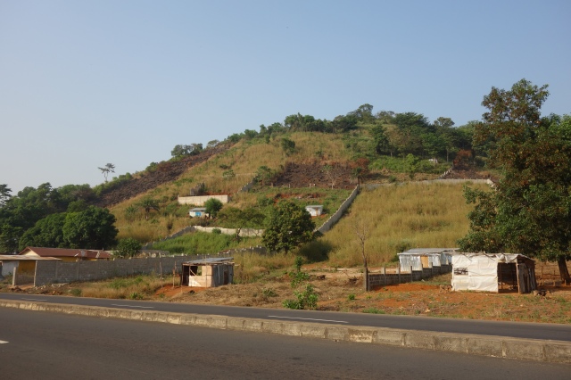
Deforested hills in Lakka, 2012
The construction boom in this area had revealed the stark economic inequalities between the well-off and poorer local residents, most of whom lived on the proceeds of artisanal fishing. While deforestation was already under way during the 1980s, it intensified during the civil war of 1991-2002, as the region received a large number of displaced people. Since the end of the conflict, people from rural provinces have migrated in large numbers to the capital region in search of livelihood opportunities. They try their luck in fishing, small-scale farming or construction-related activities, such as quarrying or sand mining (the extraction of sand from beaches). The change in land cover observed to the north of the Peninsula indicates a significant decline in vegetation between 2001 and 2015, with a shift from dense forest, to sparse forest, to grassland and built-up areas.[6] Land acquisition and unregulated building, regardless of the “legal” status of land ownership (often, that status is legally dubious or non-existent), fuels deforestation at a high pace. Due to the reliance on fuel wood for smoking fish, the fishing industry is often blamed for the decline of forest and mangrove covers. Yet, its impact has been incidental compared to the clearance of land for sale. In 2012, most of the firewood supply in Goderich was harvested in the province as a by-product of the farming cycle.[7] Similarly, whereas charcoal has become the main household fuel, the Freetown market is largely supplied by upcountry producers.[8] Nevertheless, land sales are pushing forest activities to fringe areas, such as the sparse forest, which leads to increased environmental degradation there.[9] As land speculation progresses, poorer residents will have to deal with its consequences – including an increase in land value that may impair their chances to secure properties, and a loss of income for those who depend on land-based resources (fuel wood, charcoal, granite etc.).[10] They will also face new risks, as potential natural disasters are likely to threaten those living in precarious housing conditions.
If I had journeyed down the Peninsula six years ago, along the old rocky, dusty road starting from Ogoo Farm junction, I would have taken a motorbike taxi or okada. Driving south, the okada would have taken me past Hamilton, Mambo, Mile 13, Sussex, Baw-Baw, and Number Two River. Given its decrepit condition, the road would often have been empty, except for the large trucks carrying sand, and it was often difficult and expensive for locals of those areas to get an okada. Today, the tarred road runs up to Baw-Baw junction, in the middle of the Peninsula, just before Number Two River. Once in Number Two River, there are two options to continue the journey southwards to Tokeh: to either take a bike on a road that is in such a poor condition that it currently cuts the Peninsula into two (almost) separate halves, or to cross the river estuary by boat at Number Two beach and walk around 1.5km to Tokeh, to find further local transport. This section of road has been under sporadic construction for the past few years, but it is expected that the last 7.7 kilometres separating Baw-Baw from Tokeh will finally be completed in July 2020. [11] As I rediscovered the area in 2018, therefore, the roadside landscape looked very different up to Number Two – the road construction had deviated from the dust road in some places and had brought new houses and shops along the way. Fresh hills were being deforested at a high rate, and I had the feeling that I was witnessing a continuous wave of land occupation emanating from Freetown.
Delimitations of private plots along the road, Baw-Baw, 2018
‘Development’ had come, and yet it had brought its share of new problems. Poda-poda and keke (motorized tricycles) now circulate up to Baw-Baw junction for an affordable price, and newly-implanted filling stations along the road even provide light to some villages. Still, many local residents complained that the population growth was such that they could not identify many of the new groups of people who had settled along the Peninsula road. For my host families, it was now beyond dispute that the area had become “unsafe”, and that I could not walk around – especially at night – as I used to six years before. One of my key informants told me that she was surprised at how many people got down from poda-podas at Baw-Baw junction: “…the road opened and we have buses passing by… people build up, they brush [clear land]. When I come back from town, there are many people coming down at Baw-Baw junction. I can ask them: do you live in Baw-Baw? And they say: Yes mama, I live here.” The northern part of the Peninsula is now fully connected to Freetown and has become a region that is not only attractive to people who work in construction-related activities, but also to those who work in Freetown but can barely afford to pay city rents. As the road is completed, the price of land rises, which prompts more local residents to sell family plots and become property caretakers – people who reside on private land and watch over it for a low wage. As my research assistant once told me: “People do not have work, they have nothing to do, but they have land”. In the span of six years, the average price of a town lot (50ft x 75ft) in the Number Two/Baw-Baw area had been multiplied by five – from about $1500 in 2012 to $7500 in 2018 and much more in areas close to the ocean. The central part of the Peninsula is renowned for its breath-taking beaches and attracts many investors. While land sales by locals are motivated by poverty, “big men” (state representatives, local councillors, MPs etc.) play a key role in land speculation, as they appropriate parcels of State land “legally” to establish projects or build properties.
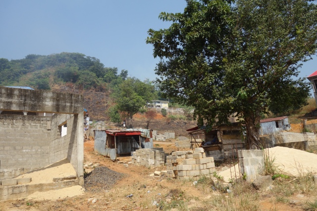
Hills in Baw-Baw – Constructions under way and pan bodi, 2018
Local residents are worried about the likely consequences of increased land acquisitions, such as the lack of land for future generations and environmental degradation, which they expressed as the lack of “breeze” and the growing heat during the dry season. They expected that unregulated access to land and rapid urbanization would affect them in the same way as it had affected other areas. In other words, the northern part of the Peninsula is now an urbanizing landscape that has to be understood as a direct extension of Freetown. In the past forty years, the capital city has mainly expanded towards the centre of the Peninsula along the roads to the east (towards Waterloo) and to the south (towards Number Two).[12] Protecting vulnerable populations and ensuring their livelihoods and rights to land in the long run will require careful urban planning.
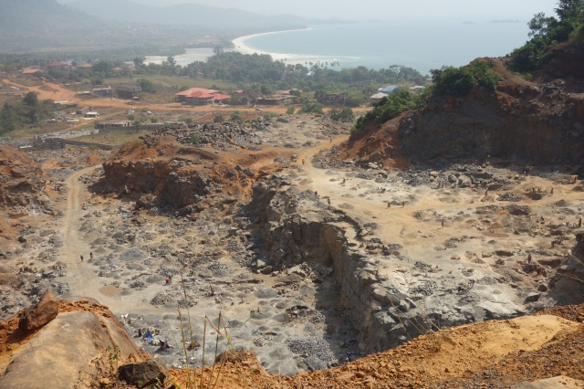
Digging the mountain for stones, quarry in Number Two River, 2018
Urban planning in the “rural” part of the Peninsula does not yet seem to be on the agenda of the current government, any more than it was on that of its predecessor. In 2008, a project for the protection of the Western Area Peninsula Forest Reserve (WAPFoR) was launched, which involved re-demarcating the boundaries of the forest reserve and establishing a 150m buffer zone. As the forest reserve is under State land ownership, this scheme reasserted government control over protected land, without making provisions for land-use rights for local people.[13]
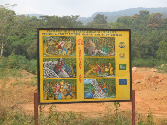
WAPFoR signboard, 2012
Successive post-war governments have denounced the erection of “illegal” structures (those without legal documents of ownership), while keeping silent about the impacts of the “legal” permits allocated by the Ministry of Lands. “Blaming the poor” for environmental degradation continues to be the best strategy for concealing the games of wealthier players in the area.[14] Deforestation has become part of a discourse about the poor and often migrant populations, who exploit forest resources for their livelihoods and who have to be “sensitized” about forest protection.[15] Bringing assistance to flood victims in Wellington, on the east of Freetown, President Maada Bio warned that people who erected structures in risky areas would be forcibly relocated, thus referring indirectly to previous demolition campaigns that targeted the “illegal” – meaning un-documented – structures of the poor.[16] Wealthier owners, who can pay to acquire title deeds from the Ministry of Lands, have, by contrast, nothing to worry about. With this baseline scenario, officials empower themselves to turn a blind eye to the disruptive entry of speculative capital. NGO projects aimed at environment protection, in 2019, continued to elude the sensitive issue of land speculation in order to avoid conflict with urban elites. Across the entire Peninsula, the allocation of private plots (with signs of ownership, such as pillars and fences) threatens the very existence of the buffer zone, which severely undermines any attempt at promoting sustainable livelihoods for local people.[17] Deforestation is a product of the severe power imbalance that exists between elites and local residents, who are not equal players in the game of land occupation. In 2018-2019, as I observed the landscape for the first time in six years, I could only feel terribly worried about a pattern of “development” that, it seemed to me, only aimed at building five-storey palaces at the expense of the local populations.
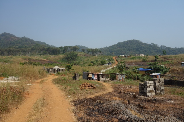
Near the buffer zone, Baw-Baw, 2018
If we continued our journey on the Peninsula after having taken the old “road” or by crossing the river at Number Two beach, we would arrive in Tokeh, a fishing town with a large beach that is now almost entirely privately-owned. On this southern half of the Peninsula, the re-paving of the tarred road connecting Tokeh and other fishing towns to Waterloo and Freetown markets was completed in 2005. This propelled the development of a pronounced economic specialization in fishing and fish smoking, and many settlements, such as Kent, Kissi Town, Mama Beach and Tombo have grown exponentially as new populations have settled over the past decade. Tombo fishing port, in particular, had already adopted an intensive commercial model during the 1980s. Between Tokeh and Mama Beach, the forest landscape seems to have been preserved and the large hills loom impressively over the visitor. Despite the road connecting via the southeast, this part of the Peninsula is further from Freetown’s centre and perceived by many as less accessible, as one needs to go around via the east road to reach those settlements. Urban encroachment may not yet be visible, but there is more to the landscape than meets the eye. In many places, pillars, fences and signboards proclaiming that plots are “state land” or property of a private owner appear discreetly, and it is certain that the completion of the Lumley-Tokeh road will prompt the sudden erection of new houses and buildings. Large state investments are also under way, such as the construction of a brand-new university campus of the Institute of Public Administration and Management (IPAM) in Bureh Town, a small (but touristic) community that will likely see its population double with the coming influx of four hundred students and a hundred staff.[18]
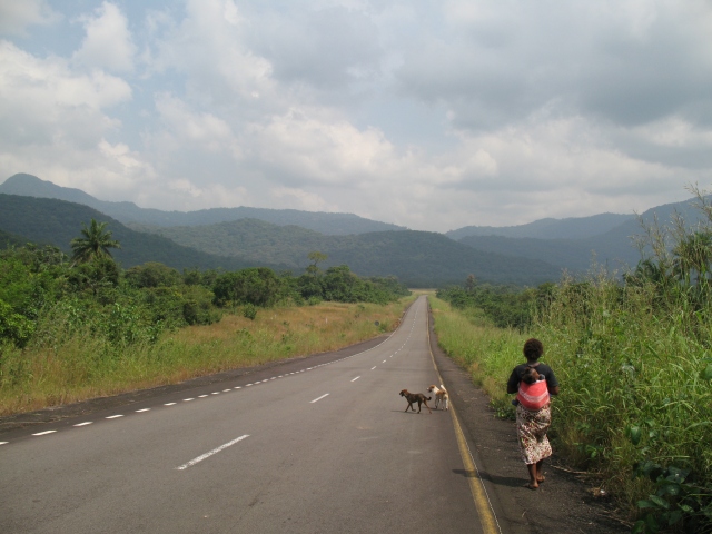
On the road from Tokeh to Waterloo, 2012
From Kissi Town to Tombo, the hills do not have much dense forest left. In 2018, deforested patches had become more visible further north, near John Obey and Black Johnson. In this area, the impacts of the fishing industry on the forest cover should be carefully weighed. Fish-sellers mostly use mangrove wood for smoking, which comes by boat from Port Loko and Bonthe District.[19] Forest wood is often gathered on sites where trees have already been cut for other reasons, such as land clearance. Similarly, although charcoal production may impact the forest to a certain extent, a good part of it also comes from the up-country supply chain. The fishing industry is constructed as the main culprit of deforestation, yet it has become clear that hillsides have been demarcated by private individuals, thus competing with projects aimed at developing livelihood activities, such as tree planting (for charcoal, firewood, or fruits).
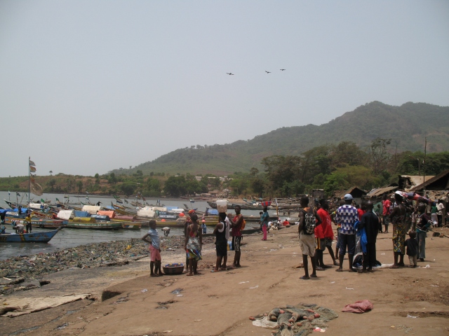
Tombo fishing harbour, 2012
Across the Peninsula, coastal settlements also suffer from the environmental effects of the construction boom. Sand mining on beaches, such as in Hamilton to the north and John Obey to the south has had detrimental effects on coastal ecosystems.[20] The intensive continuous sand mining occurring in John Obey particularly endangers the nearby tourist beaches, such as those in Bureh Town and Black Johnson. In 2018, the acceleration of ecological changes was obvious to local fishermen: the erosion of the beach prevented the river from drying up during the dry season, and the mangroves were disappearing. A group of locally-engaged men, whom I had worked with in 2011-2012 in the context of the NGO-led program against deforestation, had alerted central authorities and had spoken on national television to expose the problem. Predictably, this action failed to produce results, as there happened to be no policy implemented to provide alternative livelihoods for miners. The financial dividends that local authorities and decentralized institutions derived from this activity largely outweighed ecological concerns.
The current government has expressed its commitment to establishing Sierra Leone as a key tourist destination. To this end, it has announced several measures aimed at promoting tourism: visa on arrival (which has just been implemented), reduced airport taxes to make travels to Sierra Leone cheaper, and a proactive communication strategy. The landscape of the Peninsula is a critical asset for this policy and in several coastal settlements, particularly those around the centre of the Peninsula, local authorities have tried to promote tourism as the main economic activity, hoping that in the long-run it will replace fishing. In 2012, many of those settlements had participated in a programme to develop ecotourism as an alternative to forest activities.[21] Although this initiative was short-lived, local fishermen had started to formulate their own vision and projects regarding tourism. In 2018, domestic tourism was clearly on the rise. Number Two and Bureh Town were the two main destinations, bringing hundreds of Freetown residents for beach outings on weekends. Other beaches, such as Sussex, Baw-Baw or Tokeh, had their own smaller customer base.
What appeared clearly in 2018 was the lack of state-planned general economic orientation for the Peninsula area. The existence of competing economic strategies undermined any attempt at tackling environmental issues. As one man working in tourism and environmental protection told me, efforts to unlock the beach side’s economic potential were condemned by the lack of collective project for the region: “We want to do tourism… but Tombo and Goderich, they have made their beaches for fishing, Hamilton and John Obey, they have made their beach for sand-mining.” As each local community decides what economic activity it will push forward, discussions about ecology are bound to remain limited to the same tourism-oriented communities. With many livelihoods still dependent on fishing, and given the higher economic interests at stake, it is difficult to see how the issue of deforestation could be placed at the centre of governmental policies. To the south of the Peninsula, potential investors in tourism were worried about rumours of large fishing ports to be built in the area, as the construction of the Lumley-Tokeh road is expected to boost the fishing sector.[22] Whereas, in theory, there should be no contradiction between the promotion of tourism, the development of residential areas and the building of fish processing industries, the Peninsula is a restricted space where the pursuit of those various objectives would require a clear policy of land allocation. While people on the Peninsula joke that the colours of the Sierra Leone’s flag represent their region – with green for the forest, white for the sand and blue for the ocean – one wonders, will those colours remain attractive for tourists when the sand has been mined out and the forest has disappeared?
[1] I thank my colleagues Dr. Greg van der Horst for his insightful comments on earlier drafts of this article and Dr. David O’Kane for his careful editing.
[2] https://theconversation.com/sierra-leone-mudslide-was-a-man-made-tragedy-that-could-have-been-prevented-82783
[3] Greg van der Horst, personal communication.
[4] https://standardtimespress.org/?p=5374
[5] The results of the 2018 Sierra Leone Demographic and Health Survey have not been made available yet on Statistics Sierra Leone. Freetown (Western Area Urban District) has a population of 1, 055, 964 inhabitants according to the 2015 census. See online summary report: https://www.statistics.sl/images/StatisticsSL/Documents/final-results_-2015_population_and_housing_census.pdf
[6] See Mansaray, L. R., Huang, J. and A. Kamara (2016) “Mapping deforestation and urban expansion in Freetown, Sierra Leone, from pre- to post-war economic recovery.” Environmental Monitoring and Assessment 188 (470): 3-16. Also see Munro, P. and G. van der Horst (2012) The Domestic Trade of Timber and Fuelwood Products in Sierra Leone: Current Dynamics and Issues, Energy for Opportunity (EFO) report. Munro and van der Horst map out vegetation loss to the north of the Peninsula between 2001 and 2010.
[7] See Munro and van der Horst (2012), Op. cit., p. 71-72 and Kebbay, K., A. Thoronka and P.G. Munro (2012) Report on the Freetown Peninsula’s Fish Smoking Industry, Energy for Opportunity (EFO) /Welt Hunger Hilfe (WHH), p.8
[8] Munro and van der Horst (2012), Op. cit., p.83
[9] See Mansaray, Huang and Kamara (2016), Op. cit.
[10] See Jackson, E. A. (2015) “Deforestation on the Freetown Peninsula – A Case of Livelihood and Biodiversity Loss in the Goderich Community”, International Journal of Research in Agriculture and Forestry 2(7): 21-34, p.28-29.
[11] http://mic.gov.sl/dotnetnuke/Media/SLENA-NEWS/Twelfth-Edition/Lumley-Tokeh-Road-to-be-completed-July-2020
[12] https://blogs.worldbank.org/sustainablecities/3-challenges-building-urban-resilience-freetown
[13] See Leach, Melissa and Ian Scoones (2013) “Carbon forestry in West Africa: The politics of models, measures and verification processes” Global Environmental Change 23: 957–967, p.962.
[14] Munro, P.G. (2009) “Deforestation: Constructing problems and solutions on Sierra Leone’s Peninsula”. Journal of Political Ecology 16: 104–122.
[15] See Munro (2009), Op. cit. and Ménard, A. (2015) Sherbro Identity and the (Re-)Construction of Social and National Cohesion in Sierra Leone, unpublished PhD dissertation, Martin-Luther-Universität Halle-Wittenberg, Halle/Saale, Germany.
[16] http://www.demirrornewspaper.com/index.php/38-social-news/525-president-bio-provides-support-to-flood-victims-in-wellington-and-tombo
[17] See Hiemstra-van der Horst, Greg (2011) Consultancy report. Progress assessment of pilot phase of buffer zone development in the WAPFR core area, Welt Hunger Hilfe.
[18] https://thecalabashnewspaper.com/sierra-leone-news-50m-ipam-bureh-town-campus-set-to-kick-off/
[19] Kebbay, Thoronka and Munro (2012), Op. cit., p. 5, 12.
[20] http://www.thenewhumanitarian.org/news/2013/02/01/sand-mining-threatens-homes-and-livelihoods-sierra-leone
[21] See Ménard, A. (2015) Op. cit.
[22] http://mic.gov.sl/dotnetnuke/Media/SLENA-NEWS/Twelfth-Edition/Lumley-Tokeh-Road-to-be-completed-July-2020
